
Make a donation
Meer van Gileppe topographic map
Click on the map to display elevation.
Make a donation
About this map
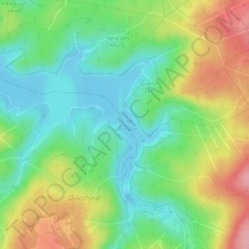
Name: Meer van Gileppe topographic map, elevation, terrain.
Location: Meer van Gileppe, Jalhay, Verviers, Luik, Wallonië, 4845, België (50.57373 5.97195 50.58968 6.00695)
Average elevation: 345 m
Minimum elevation: 297 m
Maximum elevation: 421 m
Make a donation
Other topographic maps
Click on a map to view its topography, its elevation and its terrain.
Baraque Michel
België > Luik > Verviers > Jalhay
De Baraque Michel (Duits : Michelshütte) is de naam van een herberg en de omliggende hoogveenvlakte in de Belgische Ardennen. De plaats ligt in een langlaufskigebied op een hoogte van 678 meter boven TAW (en 675 meter boven NN of NAP). Voor de Eerste Wereldoorlog was het een grenspunt met Pruisen en de…
Average elevation: 652 m
Baraque Michel
België > Luik > Verviers > Jalhay
De Baraque Michel (Duits : Michelshütte) is de naam van een herberg en de omliggende hoogveenvlakte in de Belgische Ardennen. De plaats ligt in een langlaufskigebied op een hoogte van 678 meter boven TAW (en 675 meter boven NN of NAP). Voor de Eerste Wereldoorlog was het een grenspost met Pruisen en de…
Average elevation: 652 m