
Cox's Bazar District topographic map
Interactive map
Click on the map to display elevation.
About this map
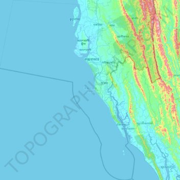
Name: Cox's Bazar District topographic map, elevation, terrain.
Location: Cox's Bazar District, Chattogram Division, Bangladesh (20.37566 91.71037 21.95504 92.42858)
Average elevation: 62 m
Minimum elevation: -2 m
Maximum elevation: 976 m
Other topographic maps
Click on a map to view its topography, its elevation and its terrain.
Chattogram
Bangladesh > Chattogram Division
Chittagong lies at 22°20′06″N 91°49′57″E / 22.33500°N 91.83250°E / 22.33500; 91.83250. It straddles the coastal foothills of the Chittagong Hill Tracts in southeastern Bangladesh. The Karnaphuli River runs along the southern banks of the city, including its central business district. The…
Average elevation: 6 m