
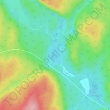
Lac Tarse topographic map
Interactive map
Click on the map to display elevation.
About this map
Name: Lac Tarse topographic map, elevation, terrain.
Average elevation: 279 m
Minimum elevation: 225 m
Maximum elevation: 371 m
Other topographic maps
Click on a map to view its topography, its elevation and its terrain.
Lac Cellier
Canada > Québec > La Vallée-de-la-Gatineau > Lac-Pythonga
Lac Cellier, Lac-Pythonga, La Vallée-de-la-Gatineau, Outaouais, Québec, Canada
Average elevation: 375 m
Lac Grey
Canada > Québec > La Vallée-de-la-Gatineau > Lac-Pythonga
Lac Grey, Lac-Pythonga, La Vallée-de-la-Gatineau, Outaouais, Québec, Canada
Average elevation: 387 m
Lac Bow
Canada > Québec > La Vallée-de-la-Gatineau > Lac-Pythonga
Lac Bow, Lac-Pythonga, La Vallée-de-la-Gatineau, Outaouais, Québec, Canada
Average elevation: 389 m
Lac Chalain
Canada > Québec > La Vallée-de-la-Gatineau > Lac-Pythonga
Lac Chalain, Lac-Pythonga, La Vallée-de-la-Gatineau, Outaouais, Québec, Canada
Average elevation: 384 m