
Thank you for supporting this site ❤️
Make a donation
Make a donation
Scranton topographic map
Click on the map to display elevation.
Thank you for supporting this site ❤️
Make a donation
Make a donation
About this map
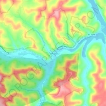
Name: Scranton topographic map, elevation, terrain.
Location: Scranton, Menifee County, Kentucky, United States (37.96731 -83.54158 38.00731 -83.50158)
Average elevation: 295 m
Minimum elevation: 220 m
Maximum elevation: 387 m
Thank you for supporting this site ❤️
Make a donation
Make a donation
Other topographic maps
Click on a map to view its topography, its elevation and its terrain.