
Thank you for supporting this site ❤️
Make a donation
Make a donation
Boticas topographic map
Click on the map to display elevation.
Thank you for supporting this site ❤️
Make a donation
Make a donation
About this map
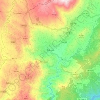
Name: Boticas topographic map, elevation, terrain.
Location: Boticas, Vila Real, Alto Tâmega, Norte, Portugal (41.64819 -7.70453 41.72819 -7.62453)
Average elevation: 674 m
Minimum elevation: 308 m
Maximum elevation: 1,105 m
Thank you for supporting this site ❤️
Make a donation
Make a donation