
Δήμος Αίγινας topographic map
Interactive map
Click on the map to display elevation.
About this map
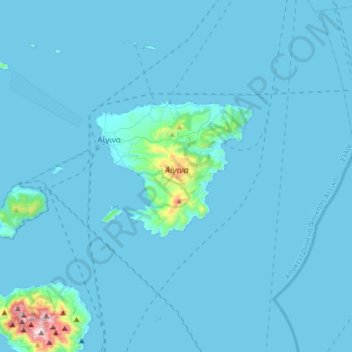
Name: Δήμος Αίγινας topographic map, elevation, terrain.
Average elevation: 26 m
Minimum elevation: -1 m
Maximum elevation: 721 m
Other topographic maps
Click on a map to view its topography, its elevation and its terrain.
Μετώπη
Griechenland > Attika > Regionalbezirk Inseln > Σκάλα
Μετώπη, Σκάλα, Δήμος Αγκιστρίου, Regionalbezirk Inseln, Region Attika, Attika, 180 10, Griechenland
Average elevation: 0 m
Methana
Griechenland > Attika > Regionalbezirk Inseln > Δημοτική Ενότητα Μεθάνων
Methana, Δημοτική Ενότητα Μεθάνων, Δήμος Τροιζηνίας - Μεθάνων, Regionalbezirk Inseln, Region Attika, Attika, 180 30, Griechenland
Average elevation: 123 m
Ägina
Griechenland > Attika > Regionalbezirk Inseln > Αγία Μαρίνα
Ägina, Αγία Μαρίνα, Δήμος Αίγινας, Regionalbezirk Inseln, Region Attika, Attika, 18010, Griechenland
Average elevation: 60 m