
Livry topographic map
Interactive map
Click on the map to display elevation.
About this map
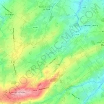
Name: Livry topographic map, elevation, terrain.
Average elevation: 143 m
Minimum elevation: 88 m
Maximum elevation: 246 m
Other topographic maps
Click on a map to view its topography, its elevation and its terrain.
La Vacquerie
France > Normandie > Calvados > Caumont-sur-Aure
La Vacquerie, Caumont-sur-Aure, Vire, Calvados, Normandie, France métropolitaine, 14240, France
Average elevation: 119 m
Caumont-l'Éventé
France > Normandie > Calvados > Caumont-sur-Aure
Caumont-l'Éventé, Caumont-sur-Aure, Vire, Calvados, Normandie, France métropolitaine, 14240, France
Average elevation: 169 m