
Thank you for supporting this site ❤️
Make a donation
Make a donation
Windermere topographic map
Click on the map to display elevation.
Thank you for supporting this site ❤️
Make a donation
Make a donation
About this map
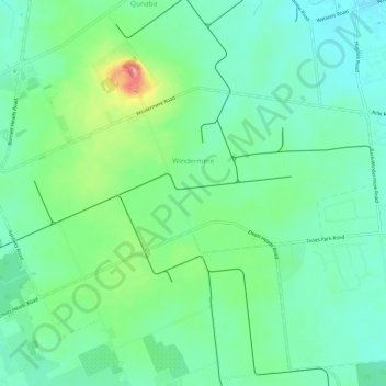
Name: Windermere topographic map, elevation, terrain.
Location: Windermere, Bundaberg Region, Queensland, Australia (-24.87500 152.40399 -24.84531 152.46408)
Average elevation: 30 m
Minimum elevation: 3 m
Maximum elevation: 95 m
Thank you for supporting this site ❤️
Make a donation
Make a donation
Other topographic maps
Click on a map to view its topography, its elevation and its terrain.
Isis River
Australia > Queensland > Bundaberg Region > South Isis > Isis River
Average elevation: 43 m
Thank you for supporting this site ❤️
Make a donation
Make a donation
Thank you for supporting this site ❤️
Make a donation
Make a donation