
Thank you for supporting this site ❤️
Make a donation
Make a donation
Khaling topographic map
Click on the map to display elevation.
Thank you for supporting this site ❤️
Make a donation
Make a donation
About this map
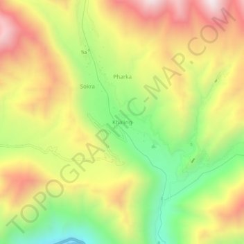
Name: Khaling topographic map, elevation, terrain.
Location: Khaling, Khaltsi, Leh district, Ladakh, India (34.31390 76.95767 34.35390 76.99767)
Average elevation: 3,506 m
Minimum elevation: 2,980 m
Maximum elevation: 4,037 m
Thank you for supporting this site ❤️
Make a donation
Make a donation
Other topographic maps
Click on a map to view its topography, its elevation and its terrain.