
Thank you for supporting this site ❤️
Make a donation
Make a donation
Mem Martins topographic map
Click on the map to display elevation.
Thank you for supporting this site ❤️
Make a donation
Make a donation
About this map
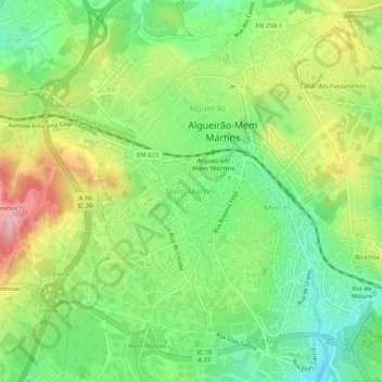
Name: Mem Martins topographic map, elevation, terrain.
Location: Mem Martins, Sintra, Lisboa, 2725-328, Portugal (38.77358 -9.36399 38.81358 -9.32399)
Average elevation: 185 m
Minimum elevation: 111 m
Maximum elevation: 292 m
Thank you for supporting this site ❤️
Make a donation
Make a donation
Other topographic maps
Click on a map to view its topography, its elevation and its terrain.