
Ighzer topographic map
Interactive map
Click on the map to display elevation.
About this map
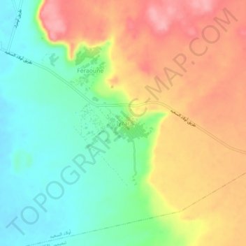
Name: Ighzer topographic map, elevation, terrain.
Location: Ighzer, Ouled Saïd, Daïra Timimoun, Timimoune, Algérie (29.35713 0.30526 29.39713 0.34526)
Average elevation: 262 m
Minimum elevation: 209 m
Maximum elevation: 322 m
Other topographic maps
Click on a map to view its topography, its elevation and its terrain.
Azekour
Algérie > Timimoune > Daïra Timimoun > Timimoun
Azekour, Timimoun, Daïra Timimoun, Timimoune, Algérie
Average elevation: 262 m
Ouled Saïd
Algérie > Timimoune > Daïra Timimoun > Ouled Saïd
Ouled Saïd, Daïra Timimoun, Timimoune, Algérie
Average elevation: 309 m