
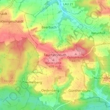
Tauchersreuth topographic map
Interactive map
Click on the map to display elevation.
About this map
Name: Tauchersreuth topographic map, elevation, terrain.
Average elevation: 390 m
Minimum elevation: 339 m
Maximum elevation: 442 m
Other topographic maps
Click on a map to view its topography, its elevation and its terrain.
Egelsee
Deutschland > Bayern > Landkreis Nürnberger Land > Lauf an der Pegnitz > Dehnberg > Egelsee
Egelsee, Dehnberg, Lauf an der Pegnitz, Landkreis Nürnberger Land, Bayern, 91207, Deutschland
Average elevation: 369 m