
Negros Oriental topographic map
Interactive map
Click on the map to display elevation.
Negros Oriental
The province's topography is characterized by low, grooved mountain ranges of which some lie close to the shoreline. At the southern end of the province is Mount Talinis, also known as Cuernos de Negros ("Horns of Negros"), which is a dormant complex volcano which rises to a height of 2,000 metres (6,600 ft). At the northern end of the province is the active Kanlaon Volcano, the highest peak of the island region with a height of 2,465 metres (8,087 ft). There are a few flatlands and plateaus in the interior to the southwest of the province, which includes the Tablas Plateau.
About this map
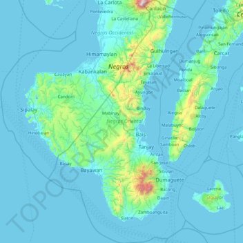
Name: Negros Oriental topographic map, elevation, terrain.
Location: Negros Oriental, Central Visayas, Philippines (8.90277 122.52862 10.42053 123.45662)
Average elevation: 116 m
Minimum elevation: -2 m
Maximum elevation: 2,356 m