
Saal topographic map
Interactive map
Click on the map to display elevation.
About this map
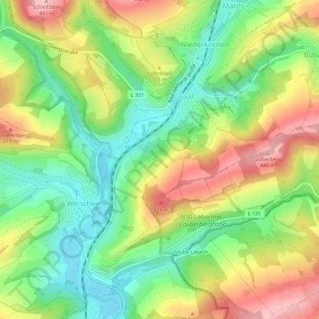
Name: Saal topographic map, elevation, terrain.
Location: Saal, Sankt Wendel, Landkreis St. Wendel, Saarland, Deutschland (49.44509 7.21197 49.46777 7.26451)
Average elevation: 351 m
Minimum elevation: 278 m
Maximum elevation: 442 m
Other topographic maps
Click on a map to view its topography, its elevation and its terrain.
Niederlinxweiler
Deutschland > Saarland > Sankt Wendel
Niederlinxweiler, Sankt Wendel, Landkreis St. Wendel, Saarland, Deutschland
Average elevation: 314 m
Hoof
Deutschland > Saarland > Sankt Wendel
Hoof, Sankt Wendel, Landkreis St. Wendel, Saarland, Deutschland
Average elevation: 374 m
Marth
Deutschland > Saarland > Sankt Wendel
Marth, Sankt Wendel, Landkreis St. Wendel, Saarland, Deutschland
Average elevation: 376 m
Winterbach
Deutschland > Saarland > Sankt Wendel
Winterbach, Sankt Wendel, Landkreis St. Wendel, Saarland, 66649, Deutschland
Average elevation: 337 m