Geolocate

Chittorgarh topographic map

Interactive map

Click on the map to display elevation.

About this map

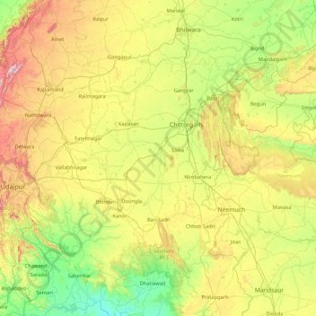
Name: Chittorgarh topographic map, elevation, terrain.

Location: Chittorgarh, Rajasthan, India (24.21845 74.10544 25.21541 75.81408)

Average elevation: 460 m

Minimum elevation: 172 m

Maximum elevation: 1,179 m

Other topographic maps

Click on a map to view its topography, its elevation and its terrain.

Chandoli

India > Rajasthan > Alwar Tehsil

Average elevation: 318 m

Brindawan

India > Rajasthan > Beejoliya Tehsil

Average elevation: 489 m

Pushkar

India > Rajasthan > Pushkar

Average elevation: 516 m

Peeli

India > Rajasthan > Peeli

Average elevation: 209 m

Ajmer

India > Rajasthan > Ajmer

Average elevation: 523 m

Chhabra

India > Rajasthan > Chhabra

Average elevation: 337 m