
Thank you for supporting this site ❤️
Make a donation
Make a donation
Hamburg topographic map
Click on the map to display elevation.
Thank you for supporting this site ❤️
Make a donation
Make a donation
About this map
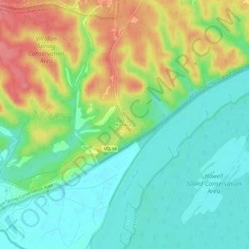
Name: Hamburg topographic map, elevation, terrain.
Location: Hamburg, Saint Charles County, Missouri, United States (38.64978 -90.75179 38.68978 -90.71179)
Average elevation: 164 m
Minimum elevation: 133 m
Maximum elevation: 215 m
Thank you for supporting this site ❤️
Make a donation
Make a donation
Other topographic maps
Click on a map to view its topography, its elevation and its terrain.
O’Fallon
United States > Missouri > Saint Charles County
O’Fallon is situated on gently rolling terrain that characterizes much of the St. Charles County landscape. The area features elevations ranging from about 400 to 600 feet above sea level, with the land gradually rising as it moves away from the Missouri River to the east. The city is interspersed with a mix…
Average elevation: 160 m
Thank you for supporting this site ❤️
Make a donation
Make a donation
Thank you for supporting this site ❤️
Make a donation
Make a donation
Thank you for supporting this site ❤️
Make a donation
Make a donation
Thank you for supporting this site ❤️
Make a donation
Make a donation
Thank you for supporting this site ❤️
Make a donation
Make a donation
Thank you for supporting this site ❤️
Make a donation
Make a donation