
Make a donation
Selayang Municipal Council topographic map
Click on the map to display elevation.
Make a donation
Selayang Municipal Council
Given its varied topography pattern and close proximity to the Titiwangsa Mountains (Banjaran Titiwangsa), Selayang is a mix of urban and countryside sceneries. Its premier natural attraction, which is well known across the country, is the Forest Research Institute Malaysia (FRIM), also known as FRIM Kepong. As a leading institute in tropical forestry research, it administers the sustainable management of the forest for the purpose of preservation and research. The institute dates back to 1926. This forest reserve area covers part of Kepong, Selayang (Bukit Lagong) and Rawang (Templer). Home for numerous species of flora and fauna. FRIM also functions as educational and recreational destination well equipped with infrastructures such as laboratory, information centre, sport facilities, a waterfall, river, trekking route, canopy walk, etc. The species are highly protected and visitors could see tags attached to trees displaying the names as well as quite rare animals on ground.
Make a donation
About this map
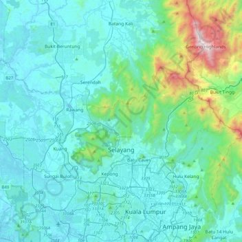
Name: Selayang Municipal Council topographic map, elevation, terrain.
Location: Selayang Municipal Council, Gombak, Selangor, Malaysia (3.19956 101.43051 3.40225 101.82975)
Average elevation: 236 m
Minimum elevation: 4 m
Maximum elevation: 1,760 m
Make a donation
Other topographic maps
Click on a map to view its topography, its elevation and its terrain.
Make a donation
Make a donation
Make a donation
Make a donation
Make a donation
Make a donation
Kampung Indian Settlement Batu Caves
Malaysia > Selangor > Selayang Municipal Council > Batu Caves
Average elevation: 68 m
Make a donation
Make a donation
Make a donation
Make a donation
Selayang
Malaysia > Selangor > Selayang
Given its varied topography pattern and close proximity to the Titiwangsa Mountains (Banjaran Titiwangsa), Selayang is a mix of urban and countryside sceneries. Its premier natural attraction, which is well-known across the country, is the Forest Research Institute Malaysia (FRIM), also known as FRIM Kepong.…
Average elevation: 201 m
Kampung Melayu Pekan Rawang
Malaysia > Selangor > Selayang Municipal Council > Rawang
Average elevation: 48 m
Make a donation
Make a donation
Make a donation
Make a donation
Make a donation
Make a donation
Kota Damansara Community Forest Reserve
Malaysia > Selangor > Petaling Jaya > Prima Damansara
Average elevation: 85 m
Make a donation
Make a donation
Make a donation
Make a donation
Make a donation
Make a donation
Kampung Indian Settlement Batu Caves
Malaysia > Selangor > Selayang Municipal Council > Batu Caves
Average elevation: 68 m
Kampung Sri Gombak Indah
Malaysia > Selangor > Selayang Municipal Council > Batu Caves
Average elevation: 84 m
Make a donation
Sungai Haji Dorani
Malaysia > Selangor > Kampung Sungai Haji Dorani > Kampung Nelayan Sungai Haji Durani
Average elevation: 3 m
Make a donation
Make a donation