
Neidenfels topographic map
Interactive map
Click on the map to display elevation.
About this map
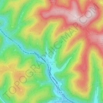
Name: Neidenfels topographic map, elevation, terrain.
Average elevation: 354 m
Minimum elevation: 170 m
Maximum elevation: 553 m
Other topographic maps
Click on a map to view its topography, its elevation and its terrain.
Weißlich
Deutschland > Rheinland-Pfalz > Landkreis Bad Dürkheim > Ruppertsberg
Weißlich, Ruppertsberg, Deidesheim, Landkreis Bad Dürkheim, Rheinland-Pfalz, 67152, Deutschland
Average elevation: 126 m
Bad Dürkheim
Deutschland > Rheinland-Pfalz > Landkreis Bad Dürkheim
Bad Dürkheim, Landkreis Bad Dürkheim, Rheinland-Pfalz, 67098, Deutschland
Average elevation: 216 m