
Ischigualasto Provincial Park topographic map
Interactive map
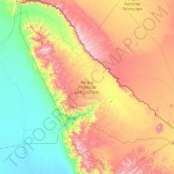
Click on the map to display elevation.
About this map
Name: Ischigualasto Provincial Park topographic map, elevation, terrain.
Average elevation: 1,258 m
Minimum elevation: 758 m
Maximum elevation: 1,929 m
Most of the park lies within the Valle Fértil Department, with a minor part in the Jachal Department of San Juan, at an altitude of about 1,300 m (4,300 ft) amsl. The park is part of the western border of the Central Sierras, and it features typical desert vegetation (bushes, cacti and some trees) which covers between 10 and 20% of the area. The climate is very dry, with rainfall mostly during the summer, and temperature extremes (minimum −10 °C or 14 °F, maximum 45 °C or 113 °F). There is a constant southern wind with a speed of 20–40 km/h (12–25 mph) after noon and until the evening, sometimes accompanied by the extremely strong Zonda wind.
Other topographic maps
Click on a map to view its topography, its elevation and its terrain.
Villa San Andrés
Villa San Andrés, Capital, San Juan, Argentina
Average elevation: 661 m
Quebrada Seca
Quebrada Seca, Iglesia, San Juan, Argentina
Average elevation: 4,334 m
Hediondo (o Rincón del Diablo)
Hediondo (o Rincón del Diablo), Iglesia, San Juan, Argentina
Average elevation: 4,025 m
Parkinson Hill
Parkinson Hill, Zonda, San Juan, 5478, Argentina
Average elevation: 1,336 m
Quebrada Seca
Quebrada Seca, Calingasta, San Juan, Argentina
Average elevation: 3,106 m
Cerro Mercedario
Cerro Mercedario, Calingasta, San Juan, Argentina
Average elevation: 6,128 m