
Le Lamentin topographic map
Interactive map
Click on the map to display elevation.
About this map
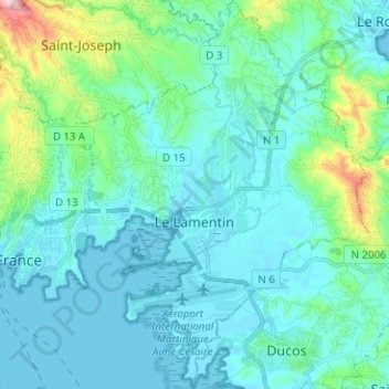
Name: Le Lamentin topographic map, elevation, terrain.
Location: Le Lamentin, Fort-de-France, Martinique, 97232, Frankrijk (14.56211 -61.03986 14.68391 -60.94484)
Average elevation: 71 m
Minimum elevation: -1 m
Maximum elevation: 480 m
Other topographic maps
Click on a map to view its topography, its elevation and its terrain.
Grand'Rivière
Frankrijk > Martinique > Grand'Rivière
Grand'Rivière, La Trinité, Martinique, 97218, Frankrijk
Average elevation: 369 m