
Birchgrove topographic map
Interactive map
Click on the map to display elevation.
About this map
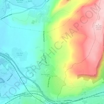
Name: Birchgrove topographic map, elevation, terrain.
Location: Birchgrove, Swansea, Wales, United Kingdom (51.65828 -3.90548 51.69392 -3.84724)
Average elevation: 103 m
Minimum elevation: 7 m
Maximum elevation: 272 m
Other topographic maps
Click on a map to view its topography, its elevation and its terrain.
Sketty
United Kingdom > Wales > Swansea > Swansea
Sketty, Swansea, Wales, United Kingdom
Average elevation: 69 m
Singleton Park
United Kingdom > Wales > Swansea > Swansea
Singleton Park, Sketty, Swansea, Wales, United Kingdom
Average elevation: 40 m
Kilvey Hill
United Kingdom > Wales > Swansea > Swansea
Kilvey Hill, Swansea, Wales, SA1 8ED, United Kingdom
Average elevation: 50 m