
Chillogallo topographic map
Interactive map
Click on the map to display elevation.
About this map
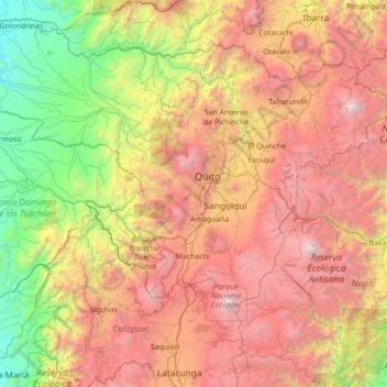
Name: Chillogallo topographic map, elevation, terrain.
Location: Chillogallo, Pichincha, 170708, Équateur (-0.98685 -79.26263 0.41315 -77.86263)
Average elevation: 2,422 m
Minimum elevation: 120 m
Maximum elevation: 5,818 m
Other topographic maps
Click on a map to view its topography, its elevation and its terrain.
Malchinguí
Équateur > Pichincha > Pedro Moncayo Canton
Malchinguí, Malchingui, Pedro Moncayo Canton, Pichincha, 171010, Équateur
Average elevation: 2,821 m
Mariscal Sucre
Mariscal Sucre, Pichincha, 170143, Équateur
Average elevation: 2,481 m
La Ecuatoriana
La Ecuatoriana, Pichincha, 170707, Équateur
Average elevation: 2,425 m