
Thank you for supporting this site ❤️
Make a donation
Make a donation
Marzás topographic map
Click on the map to display elevation.
Thank you for supporting this site ❤️
Make a donation
Make a donation
About this map
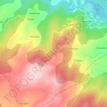
Name: Marzás topographic map, elevation, terrain.
Location: Marzás, Carballedo, Chantada, Lugo, Galicien, 27528, Spanien (42.48003 -7.80851 42.50786 -7.78306)
Average elevation: 622 m
Minimum elevation: 458 m
Maximum elevation: 758 m
Thank you for supporting this site ❤️
Make a donation
Make a donation
Other topographic maps
Click on a map to view its topography, its elevation and its terrain.