
Thank you for supporting this site ❤️
Make a donation
Make a donation
Ponts topographic map
Click on the map to display elevation.
Thank you for supporting this site ❤️
Make a donation
Make a donation
About this map
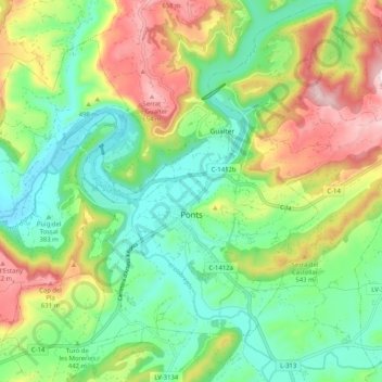
Name: Ponts topographic map, elevation, terrain.
Location: Ponts, Noguera, Lérida, Cataluña, España (41.89025 1.11989 41.95096 1.22237)
Average elevation: 455 m
Minimum elevation: 329 m
Maximum elevation: 673 m
Thank you for supporting this site ❤️
Make a donation
Make a donation
Other topographic maps
Click on a map to view its topography, its elevation and its terrain.
Thank you for supporting this site ❤️
Make a donation
Make a donation
Thank you for supporting this site ❤️
Make a donation
Make a donation