
Crans-Montana topographic map
Interactive map
Click on the map to display elevation.
About this map
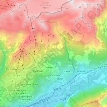
Name: Crans-Montana topographic map, elevation, terrain.
Location: Crans-Montana, Siders, Wallis, 3960, Schweiz (46.27218 7.45877 46.38897 7.58017)
Average elevation: 1,660 m
Minimum elevation: 508 m
Maximum elevation: 3,155 m
Sowohl ab Sitten als auch von Siders aus führen kurvenreiche Zufahrtsstrassen von der durch das Rhônetal verlaufenden Autobahn A9. Auf 13 Kilometern wird dabei eine Höhendifferenz von 1000 Metern überwunden. Die Auffahrt durch die Rebhänge und Alpwiesen dauert von Sitten aus etwa 35, von Siders aus etwa 20 Minuten.
Other topographic maps
Click on a map to view its topography, its elevation and its terrain.
Plans-Mayens
Schweiz > Wallis > Siders > Plans-Mayens
Plans-Mayens, Leis, Siders, Wallis, 3960, Schweiz
Average elevation: 1,501 m