
iraty-Pottok topographic map
Interactive map
Click on the map to display elevation.
About this map
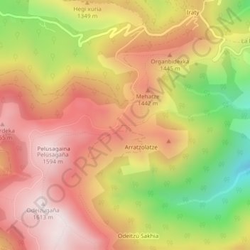
Name: iraty-Pottok topographic map, elevation, terrain.
Average elevation: 1,304 m
Minimum elevation: 863 m
Maximum elevation: 1,615 m
Other topographic maps
Click on a map to view its topography, its elevation and its terrain.
Col Bagargiak
France > Nouvelle-Aquitaine > Pyrénées-Atlantiques > Larrau > Iraty
Col Bagargiak, Iraty, Larrau, Oloron-Sainte-Marie, Pyrénées-Atlantiques, Nouvelle-Aquitaine, France métropolitaine, 64560, France
Average elevation: 1,202 m