
Thank you for supporting this site ❤️
Make a donation
Make a donation
Reay topographic map
Click on the map to display elevation.
Thank you for supporting this site ❤️
Make a donation
Make a donation
About this map
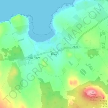
Name: Reay topographic map, elevation, terrain.
Location: Reay, Caithness, Scotland, KW14 7RE, United Kingdom (58.53860 -3.79597 58.57860 -3.75597)
Average elevation: 32 m
Minimum elevation: 0 m
Maximum elevation: 119 m
Thank you for supporting this site ❤️
Make a donation
Make a donation
Other topographic maps
Click on a map to view its topography, its elevation and its terrain.