
Thank you for supporting this site ❤️
Make a donation
Make a donation
Hadfield topographic map
Click on the map to display elevation.
Thank you for supporting this site ❤️
Make a donation
Make a donation
About this map
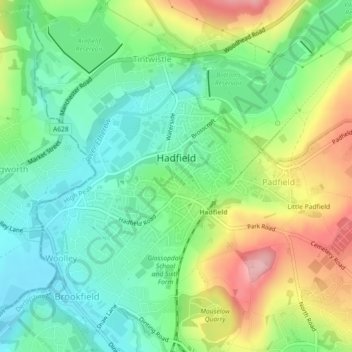
Name: Hadfield topographic map, elevation, terrain.
Location: Hadfield, High Peak, Derbyshire, England, United Kingdom (53.45706 -1.98808 53.46886 -1.96043)
Average elevation: 174 m
Minimum elevation: 118 m
Maximum elevation: 272 m
Thank you for supporting this site ❤️
Make a donation
Make a donation
Other topographic maps
Click on a map to view its topography, its elevation and its terrain.
Birch Vale
United Kingdom > England > Derbyshire > High Peak > New Mills > Hayfield
Average elevation: 251 m
Thank you for supporting this site ❤️
Make a donation
Make a donation