
Thank you for supporting this site ❤️
Make a donation
Make a donation
Lapela topographic map
Click on the map to display elevation.
Thank you for supporting this site ❤️
Make a donation
Make a donation
About this map
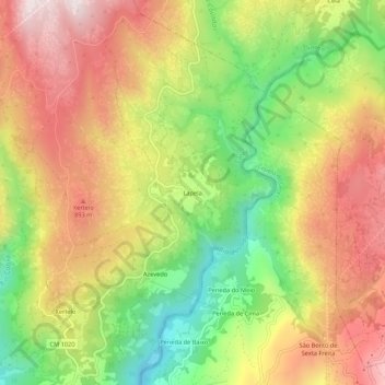
Name: Lapela topographic map, elevation, terrain.
Location: Lapela, Cabril, Montalegre, Vila Real, Portugal (41.72815 -8.01407 41.76815 -7.97407)
Average elevation: 714 m
Minimum elevation: 384 m
Maximum elevation: 1,027 m
Thank you for supporting this site ❤️
Make a donation
Make a donation
Other topographic maps
Click on a map to view its topography, its elevation and its terrain.