
Pouch topographic map
Interactive map
Click on the map to display elevation.
About this map
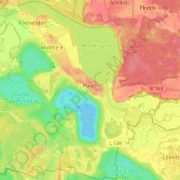
Name: Pouch topographic map, elevation, terrain.
Location: Pouch, Muldestausee, Anhalt-Bitterfeld, Saxe-Anhalt, Allemagne (51.61289 12.38749 51.63512 12.42011)
Average elevation: 75 m
Minimum elevation: 48 m
Maximum elevation: 100 m
Other topographic maps
Click on a map to view its topography, its elevation and its terrain.
Muldestausee
Allemagne > Saxe-Anhalt > Muldestausee
Muldestausee, Anhalt-Bitterfeld, Saxe-Anhalt, 06774, Allemagne
Average elevation: 90 m