Geolocate

Vinton County topographic map

Click on the map to display elevation.

About this map

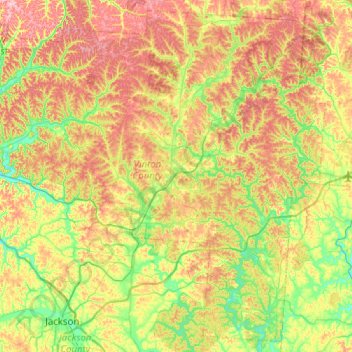
Name: Vinton County topographic map, elevation, terrain.

Location: Vinton County, Ohio, United States (39.02830 -82.76292 39.39602 -82.26014)

Average elevation: 253 m

Minimum elevation: 180 m

Maximum elevation: 352 m

Other topographic maps

Click on a map to view its topography, its elevation and its terrain.

Columbus

United States > Ohio > Franklin County > Columbus

The confluence of the Scioto and Olentangy rivers is just north-west of Downtown Columbus. Several smaller tributaries course through the Columbus metropolitan area, including Alum Creek, Big Walnut Creek, and Darby Creek. Columbus is considered to have relatively flat topography thanks to a large glacier that…

Average elevation: 255 m

Campbell Hill

United States > Ohio > Logan County > Bellefontaine

Campbell Hill is, at 1,549.09 feet (472.16 m), the highest point in elevation in the U.S. state of Ohio. Campbell Hill is located within the city of Bellefontaine, 2 miles (3.2 km) northeast of downtown.

Average elevation: 444 m

Rose Lake

United States > Ohio > Hocking County

Average elevation: 295 m

Burr Oak State Park

United States > Ohio > Morgan County

Average elevation: 251 m

Sagamore Hills

United States > Ohio > Summit County

Average elevation: 264 m

Beaver Island

United States > Ohio > Mahoning County > Boardman

Average elevation: 328 m

Cleveland

United States > Ohio > Cuyahoga County > Cleveland

The land rises quickly from the lake shore elevation of 569 feet. Public Square, less than one mile (1.6 km) inland, sits at an elevation of 650 feet (198 m), and Hopkins Airport, 5 miles (8 km) inland from the lake, is at an elevation of 791 feet (241 m).

Average elevation: 221 m

Cincinnati

United States > Ohio > Hamilton County

Cincinnati has several standard modes of transportation including sidewalks, roads, public transit, bicycle paths and airports. The city's hills preclude the regular street grid common to many cities built up in the 19th century, and outside of the downtown basin, regular street grids are rare except for in…

Average elevation: 225 m

Towner's Woods

United States > Ohio > Portage County

Average elevation: 329 m

Hammondsville

United States > Ohio > Jefferson County

Average elevation: 293 m

Buena Vista

United States > Ohio > Scioto County

Average elevation: 220 m

Spring Mountain

United States > Ohio > Coshocton County

Average elevation: 326 m

Moss Run

United States > Ohio > Washington County

Average elevation: 250 m

Fort McKinley

United States > Ohio > Montgomery County > Dayton

Average elevation: 273 m

Claylick

United States > Ohio > Licking County

Average elevation: 258 m

Brukner Park

United States > Ohio > Miami County > Troy

Average elevation: 256 m

Homer

United States > Ohio > Licking County

Average elevation: 311 m

Pharisburg

United States > Ohio > Union County

Average elevation: 292 m

Mount Lookout

United States > Ohio > Auglaize County

Average elevation: 316 m

Crescent

United States > Ohio > Belmont County

Average elevation: 314 m

Alfred

United States > Ohio > Meigs County

Average elevation: 228 m

Chaska Beach

United States > Ohio > Erie County > Huron

Average elevation: 177 m

Dillon Lake

United States > Ohio > Muskingum County

Average elevation: 258 m

North Baltimore

United States > Ohio > Wood County

Average elevation: 219 m

Avon Center

United States > Ohio > Lorain County > Avon

Average elevation: 201 m

Tedrow

United States > Ohio > Fulton County > Tedrow

Average elevation: 232 m

Brookville

United States > Ohio > Athens County

Average elevation: 236 m

The Highlands

United States > Ohio > Muskingum County

Average elevation: 280 m

Oak Ridge

United States > Ohio > Montgomery County > Centerville

Average elevation: 298 m

Hickory Grove

United States > Ohio > Ottawa County

Average elevation: 174 m

Mayfield

United States > Ohio > Butler County > Middletown

Average elevation: 212 m

Russell

United States > Ohio > Highland County

Average elevation: 321 m

Vulcan

United States > Ohio > Lucas County > Toledo

Average elevation: 190 m

Newbury

United States > Ohio > Geauga County

Average elevation: 367 m

Welshfield

United States > Ohio > Geauga County > Troy Township

Average elevation: 352 m

Camp Crowell Dam

United States > Ohio > Summit County

Average elevation: 355 m

East Cambridge

United States > Ohio > Guernsey County > Cambridge

Average elevation: 261 m

Summit Park

United States > Ohio > Hamilton County > Blue Ash

Average elevation: 254 m

Windsor

United States > Ohio > Ashtabula County

Average elevation: 266 m

Huntcrest Acres

United States > Ohio > Hamilton County

Average elevation: 252 m

Cuyahoga River

United States > Ohio > Cuyahoga County > Cleveland

The upper Cuyahoga River, starting at 1,093 feet (333 m) over 84 miles (135 km) from its mouth, drops in elevation fairly steeply, creating falls and rapids in some places; the lower Cuyahoga River only drops several feet along the last several miles of the lower river to 571 feet (174 m) at the mouth on Lake…

Average elevation: 196 m

Lemert

United States > Ohio > Crawford County

Average elevation: 292 m

Eldean

United States > Ohio > Miami County

Average elevation: 266 m

Lake Cable

United States > Ohio > Stark County

Average elevation: 340 m

Herbert Corners

United States > Ohio > Mahoning County

Average elevation: 344 m

Fox Acres

United States > Ohio > Hamilton County > Cincinnati

Average elevation: 261 m

Rose Lake Dam

United States > Ohio > Hocking County

Average elevation: 297 m

Willow Glen

United States > Ohio > Tuscarawas County > Dover

Average elevation: 281 m

Colton

United States > Ohio > Henry County

Average elevation: 206 m

Creola

United States > Ohio > Vinton County

Average elevation: 256 m

Williamsfield

United States > Ohio > Ashtabula County

Average elevation: 345 m

Hill Grove

United States > Ohio > Darke County

Average elevation: 327 m

Post Town

United States > Ohio > Montgomery County > Trotwood

Average elevation: 272 m

Bridgetown

United States > Ohio > Hamilton County > Bridgetown

Average elevation: 263 m

Ohmer Park

United States > Ohio > Montgomery County > Dayton

Average elevation: 270 m

Columbus Feeder

United States > Ohio > Franklin County > Columbus

Average elevation: 213 m

Walnut Creek

United States > Ohio > Holmes County

Average elevation: 327 m

Little York

United States > Ohio > Montgomery County

Average elevation: 269 m

Mount Adams

United States > Ohio > Hamilton County > Cincinnati

Average elevation: 181 m

Hemlock Falls

United States > Ohio > Richland County

Average elevation: 368 m

Novelty

United States > Ohio > Geauga County

Average elevation: 337 m

Westgate Park

United States > Ohio > Franklin County > Columbus

Average elevation: 253 m

Oakgrove

United States > Ohio > Clark County

Average elevation: 300 m

Curtice

United States > Ohio > Ottawa County

Average elevation: 182 m

Pfeiffer

United States > Ohio > Hardin County

Average elevation: 294 m

Serpent Mound

United States > Ohio > Adams County

The mound is located on the site of a classic astrobleme, an ancient meteorite impact structure. One of the strongest clues to the impact origin of this structure is in the pattern of disruption of sedimentary strata. In the center of the structure, strata have been uplifted several hundred feet, in much the…

Average elevation: 226 m

Lake Buckhorn

United States > Ohio > Holmes County > Clark

Average elevation: 300 m

Appleton

United States > Ohio > Licking County

Average elevation: 350 m

New California

United States > Ohio > Union County

Average elevation: 299 m

Bevis

United States > Ohio > Hamilton County

Average elevation: 265 m

Moorefield

United States > Ohio > Harrison County

Average elevation: 319 m

New Rumley

United States > Ohio > Harrison County

Average elevation: 349 m

Camp Dennison

United States > Ohio > Hamilton County

Average elevation: 201 m

Yelverton

United States > Ohio > Hardin County

Average elevation: 329 m

Berlin

United States > Ohio > Holmes County

Average elevation: 357 m

Miamitown

United States > Ohio > Hamilton County

Average elevation: 192 m