
Make a donation
Meeker topographic map
Click on the map to display elevation.
Make a donation
Meeker
According to the United States Census Bureau, the town has a total area of 2.9 square miles (7.5 km2), all of it land. The town is situated on the White River at an elevation of 6,250 feet above sea level.
Make a donation
About this map
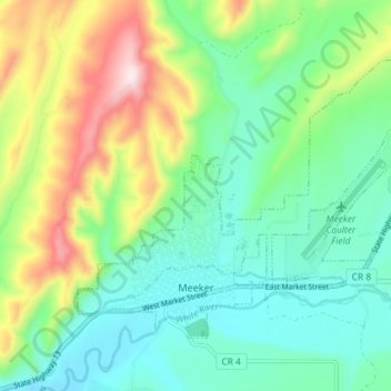
Name: Meeker topographic map, elevation, terrain.
Location: Meeker, Rio Blanco County, Colorado, United States (40.03028 -107.93516 40.07082 -107.86238)
Average elevation: 2,016 m
Minimum elevation: 1,879 m
Maximum elevation: 2,326 m
Make a donation
Other topographic maps
Click on a map to view its topography, its elevation and its terrain.
Sleepy Cat Peak
United States > Colorado > Rio Blanco County
Sleepy Cat Peak, elevation 10,853 ft (3,308 m), is a summit in the Flat Tops of northwest Colorado. The mountain is east of Meeker in the White River National Forest of Rio Blanco County.
Average elevation: 3,090 m
Make a donation