
Puncak Jaya topographic map
Interactive map
Click on the map to display elevation.
About this map
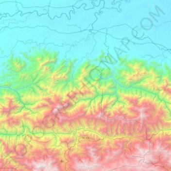
Name: Puncak Jaya topographic map, elevation, terrain.
Location: Puncak Jaya, Papua, Indonesien (-3.86665 137.38506 -3.11215 138.30448)
Average elevation: 1,306 m
Minimum elevation: 43 m
Maximum elevation: 4,090 m
Der Puncak Jaya (Bahasa Indonesia: „Siegesgipfel“), auch Carstensz-Pyramide und früher Djalaspitze genannt, ist mit 4884 m Höhe der höchste Berg Ozeaniens und weltweit der höchste Berg auf einer Insel. Er liegt in der indonesischen Provinz Papua, einer der beiden Provinzen in Westneuguinea der Insel Neuguinea. Der Puncak Jaya gehört zur Sudirman Range, die ein Teil des Maokegebirges ist. Dieses ist alpidischen Ursprungs und durch das Abtauchen der Pazifischen Platte unter die Indisch-Australische Platte entstanden.
Other topographic maps
Click on a map to view its topography, its elevation and its terrain.
Kepulauan Yapen
Kepulauan Yapen, Papua, Western New Guinea, 98211, Indonesien
Average elevation: 57 m
Pulau Sorenarwa
Indonesien > Papua > Kepulauan Yapen
Pulau Sorenarwa, Kepulauan Yapen, Papua, 98211, Indonesien
Average elevation: 39 m
Mamberamo
Mamberamo, Mamberamo Raya, Papua, 99376, Indonesien
Average elevation: 173 m
Biak Kota
Indonesien > Papua > Biak Kota
Biak Kota, Biak Numfor, Papua, 98111, Indonesien
Average elevation: 21 m
Carstensz-Pyramide
Carstensz-Pyramide, Mimika, Papua, Indonesien
Average elevation: 4,265 m