
Brauneberg topographic map
Interactive map
Click on the map to display elevation.
About this map
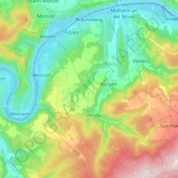
Name: Brauneberg topographic map, elevation, terrain.
Average elevation: 290 m
Minimum elevation: 107 m
Maximum elevation: 647 m
Other topographic maps
Click on a map to view its topography, its elevation and its terrain.
Neumagen
Allemagne > Rhénanie-Palatinat > Landkreis Bernkastel-Wittlich > Neumagen-Dhron
Neumagen, Neumagen-Dhron, Bernkastel-Kues, Landkreis Bernkastel-Wittlich, Rhénanie-Palatinat, 54347, Allemagne
Average elevation: 215 m
Merscheid
Allemagne > Rhénanie-Palatinat > Landkreis Bernkastel-Wittlich > Morbach
Merscheid, Morbach, Landkreis Bernkastel-Wittlich, Rhénanie-Palatinat, 54497, Allemagne
Average elevation: 471 m
Erden
Allemagne > Rhénanie-Palatinat > Landkreis Bernkastel-Wittlich > Erden
Erden, Bernkastel-Kues, Landkreis Bernkastel-Wittlich, Rhénanie-Palatinat, Allemagne
Average elevation: 207 m
Piesport
Allemagne > Rhénanie-Palatinat > Landkreis Bernkastel-Wittlich > Piesport
Piesport, Bernkastel-Kues, Landkreis Bernkastel-Wittlich, Rhénanie-Palatinat, 54498, Allemagne
Average elevation: 246 m
Lösnich
Allemagne > Rhénanie-Palatinat > Landkreis Bernkastel-Wittlich > Lösnich
Lösnich, Bernkastel-Kues, Landkreis Bernkastel-Wittlich, Rhénanie-Palatinat, Allemagne
Average elevation: 210 m
Veldenz
Allemagne > Rhénanie-Palatinat > Landkreis Bernkastel-Wittlich
Veldenz, Bernkastel-Kues, Landkreis Bernkastel-Wittlich, Rhénanie-Palatinat, Allemagne
Average elevation: 375 m
Bernkastel-Kues
Allemagne > Rhénanie-Palatinat > Landkreis Bernkastel-Wittlich
Bernkastel-Kues, Landkreis Bernkastel-Wittlich, Rhénanie-Palatinat, 54470, Allemagne
Average elevation: 269 m
Esch
Allemagne > Rhénanie-Palatinat > Landkreis Bernkastel-Wittlich
Esch, Wittlich-Land, Landkreis Bernkastel-Wittlich, Rhénanie-Palatinat, Allemagne
Average elevation: 174 m
Malborn
Allemagne > Rhénanie-Palatinat > Landkreis Bernkastel-Wittlich
Malborn, Thalfang am Erbeskopf, Landkreis Bernkastel-Wittlich, Rhénanie-Palatinat, 54426, Allemagne
Average elevation: 548 m