Geolocate

Waukon topographic map

Interactive map

Click on the map to display elevation.

About this map

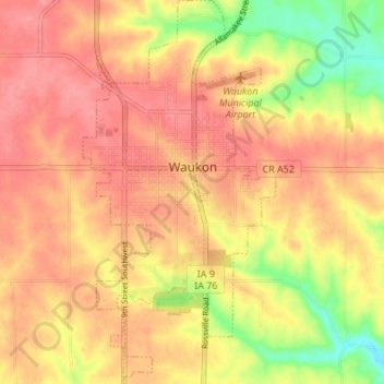
Name: Waukon topographic map, elevation, terrain.

Location: Waukon, Allamakee County, Iowa, 52172, United States (43.24146 -91.49526 43.29094 -91.46112)

Average elevation: 373 m

Minimum elevation: 318 m

Maximum elevation: 402 m

Other topographic maps

Click on a map to view its topography, its elevation and its terrain.

New Albin

United States > Iowa > Allamakee County

New Albin, Allamakee County, Iowa, United States

Average elevation: 209 m

Lansing

United States > Iowa > Allamakee County

Lansing, Allamakee County, Iowa, United States

Average elevation: 228 m

Dorchester

United States > Iowa > Allamakee County

Dorchester, Allamakee County, Iowa, 52140, United States

Average elevation: 300 m

Postville

United States > Iowa > Allamakee County

Postville, Allamakee County, Iowa, United States

Average elevation: 355 m

Elon

United States > Iowa > Allamakee County

Elon, Allamakee County, Iowa, United States

Average elevation: 335 m

Waterville

United States > Iowa > Allamakee County

Waterville, Allamakee County, Iowa, United States

Average elevation: 291 m

Harpers Ferry

United States > Iowa > Allamakee County

Harpers Ferry, Allamakee County, Iowa, United States

Average elevation: 214 m