
Thank you for supporting this site ❤️
Make a donation
Make a donation
Blegny topographic map
Click on the map to display elevation.
Thank you for supporting this site ❤️
Make a donation
Make a donation
Blegny
Blegny ligt op het Plateau van Herve, op een hoogte van ongeveer 220 meter. Ten zuiden van de kern stroomt de Bolland in westelijke richting. Ten gevolge van de steenkoolwinning heeft enige verstedelijking plaatsgevonden. Ook de inwijking van gastarbeiders heeft dit geaccentueerd. Zo zijn er twee moskeeën in Blegny.
Thank you for supporting this site ❤️
Make a donation
Make a donation
About this map
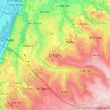
Name: Blegny topographic map, elevation, terrain.
Location: Blegny, Luik, Wallonië, 4670, België (50.63272 5.68524 50.71272 5.76524)
Average elevation: 187 m
Minimum elevation: 53 m
Maximum elevation: 304 m
Thank you for supporting this site ❤️
Make a donation
Make a donation
Other topographic maps
Click on a map to view its topography, its elevation and its terrain.