
Thank you for supporting this site ❤️
Make a donation
Make a donation
Osor topographic map
Click on the map to display elevation.
Thank you for supporting this site ❤️
Make a donation
Make a donation
Osor
Osor liegt etwa 24 Kilometer westsüdwestlich von Girona und etwa 88 Kilometer nordöstlich von Barcelona in einer Höhe von ca. 340 m. Im Norden der Gemeinde fließt der Ter.
Thank you for supporting this site ❤️
Make a donation
Make a donation
About this map
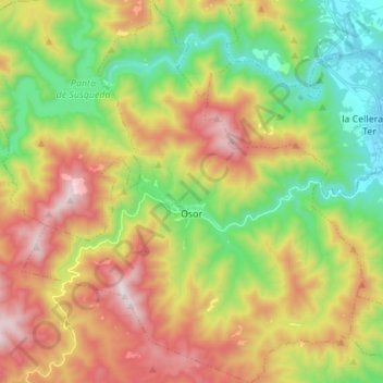
Name: Osor topographic map, elevation, terrain.
Location: Osor, la Selva, Girona, Katalonien, Spanien (41.89996 2.49628 42.00175 2.61886)
Average elevation: 584 m
Minimum elevation: 152 m
Maximum elevation: 1,161 m
Thank you for supporting this site ❤️
Make a donation
Make a donation