
Make a donation
Jengish Chokusu topographic map
Click on the map to display elevation.
Make a donation
Jengish Chokusu
Jengish Chokusu or Victory Peak is the highest mountain in the Tian Shan mountain system in Central Asia at 7,439 metres (24,406 ft). It lies on the China–Kyrgyzstan border between the Ak-Suu District in the Issyk-Kul Region of far Eastern Kyrgyzstan and Wensu County, Xinjiang, China. It is part of the Kakshaal Too, the highest part of the Tian Shan, and is southeast of lake Issyk-Kul. Jengish Chokusu is the 16th most topographically prominent peak on Earth.
Make a donation
About this map
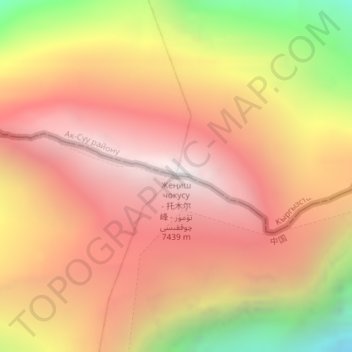
Name: Jengish Chokusu topographic map, elevation, terrain.
Location: Jengish Chokusu, Ak-Suu District, Issyk-Kul Region, Kyrgyzstan (42.03461 80.12866 42.03471 80.12876)
Average elevation: 6,681 m
Minimum elevation: 5,411 m
Maximum elevation: 7,456 m
Make a donation
Other topographic maps
Click on a map to view its topography, its elevation and its terrain.
Ala-Köl
Kyrgyzstan > Issyk-Kul Region > Ak-Suu District
Ala-Köl (Kyrgyz: Ала-Көл, also Алакөл, Russian: Ала-Куль, romanized: Ala-Kul) is a rock-dammed lake in the Terskey Alatau mountain range in the Ak-Suu District of the Issyk-Kul Region in Kyrgyzstan. It lies at an altitude of 3,532 m (11,588 ft). It is 2.8 km (1.7 mi) long and 600–700 m…
Average elevation: 3,703 m