
Make a donation
Morro Reuter topographic map
Click on the map to display elevation.
Make a donation
Morro Reuter
Morro Reuter é um município brasileiro do estado do Rio Grande do Sul. Localiza-se a uma latitude 29º32'17" sul e a uma longitude 51º04'51" oeste, estando a uma altitude de 492 metros. Sua altitude máxima atinge os 700 metros. Compõem o município de Morro Reuter as seguntes localidades(bairros): Walachai, São José do Herval, Muckental, Fazenda Padre Eterno, Franckental, Birckenthal, Picada São Paulo, Linha Cristo Rei, Batatenthal, Planalto, Belvedere, Linha Görgen e Centro.
Make a donation
About this map
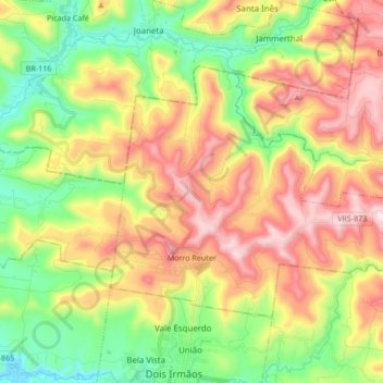
Name: Morro Reuter topographic map, elevation, terrain.
Average elevation: 348 m
Minimum elevation: 22 m
Maximum elevation: 766 m
Make a donation
Other topographic maps
Click on a map to view its topography, its elevation and its terrain.
Canoas
Brasil > Rio Grande do Sul > Região Metropolitana de Porto Alegre > Canoas
Atinge uma altitude de oito metros ao nível do mar. Em seu território correm as águas dos rios Gravataí e Sinos.
Average elevation: 30 m
Pico do Monte Negro
Brasil > Rio Grande do Sul > São José dos Ausentes
Está a 1410 m de altitude[carece de fontes?] (outras fontes referem 1403 m), na borda do cânion de mesmo nome, a 45 km da sede de São José dos Ausentes, com acesso pela estrada Municipal Silveira.
Average elevation: 1,188 m
Make a donation
Porto Alegre
Brasil > Rio Grande do Sul > Região Metropolitana de Porto Alegre > Porto Alegre
Geologicamente a estrutura do terreno porto-alegrense é muito antiga. A cidade está localizada dentro dos limites da Bacia do Paraná, uma extensa bacia sedimentar que se estende para o norte até o centro do Brasil, cujos primeiros sedimentos foram depositados no Paleozoico, com vários acúmulos…
Average elevation: 27 m
Caxias do Sul
Brasil > Rio Grande do Sul > Caxias do Sul
Caxias do Sul é um município brasileiro do estado do Rio Grande do Sul. Localiza-se no nordeste do estado a uma altitude de 817 metros sobre o nível do mar, sendo a cidade mais importante da Serra Gaúcha; a segunda cidade gaúcha mais populosa, superada apenas pela capital Porto Alegre; e a 47ª maior…
Average elevation: 637 m
Make a donation
Make a donation
Morro Santana
Brasil > Rio Grande do Sul > Região Metropolitana de Porto Alegre > Porto Alegre
Average elevation: 166 m
Make a donation
Concórdia
Brasil > Rio Grande do Sul > Região Metropolitana de Porto Alegre > Parobé
Average elevation: 139 m
Make a donation
Três Irmãos
Brasil > Rio Grande do Sul > Região Metropolitana de Porto Alegre > Taquara
Average elevation: 402 m
Make a donation
Santa Cruz do Pinhal
Brasil > Rio Grande do Sul > Região Metropolitana de Porto Alegre > Taquara
Average elevation: 222 m
Make a donation
Monjolo
Brasil > Rio Grande do Sul > Região Metropolitana de Porto Alegre > Santo Antônio da Patrulha
Average elevation: 52 m
Praça da Bíblia
Brasil > Rio Grande do Sul > Região Metropolitana de Porto Alegre > Cachoeirinha
Average elevation: 44 m
Make a donation
Morro do Farol
Brasil > Rio Grande do Sul > Aglomeração Urbana do Litoral Norte > Torres
Average elevation: 4 m
Paquete
Brasil > Rio Grande do Sul > Região Metropolitana de Porto Alegre > Capela de Santana
Average elevation: 33 m
Make a donation
Rio dos Sinos
Brasil > Rio Grande do Sul > Região Metropolitana de Porto Alegre > Sapiranga
Average elevation: 28 m
Make a donation
Mirante do Morro da Borússia
Brasil > Rio Grande do Sul > Aglomeração Urbana do Litoral Norte > Osório
Average elevation: 197 m
Praça das Carretas
Brasil > Rio Grande do Sul > Aglomeração Urbana do Litoral Norte > Osório
Average elevation: 22 m
Parque Alim Pedro
Brasil > Rio Grande do Sul > Região Metropolitana de Porto Alegre > Porto Alegre
Average elevation: 28 m
Morro Grande
Brasil > Rio Grande do Sul > Região Metropolitana de Porto Alegre > Viamão
Average elevation: 39 m
Make a donation
Make a donation
Make a donation
Make a donation
Praça Doutor Jurandir Barcellos da Silva
Brasil > Rio Grande do Sul > Região Metropolitana de Porto Alegre > Porto Alegre
Average elevation: 57 m
Make a donation
Praça Conde de Porto Alegre
Brasil > Rio Grande do Sul > Região Metropolitana de Porto Alegre > Porto Alegre
Em 1919 sua topografia foi reformulada, diminuindo-se a declividade do terreno. Na administração do prefeito Telmo Thompson Flores (1969-1975) o espaço sofreu nova reforma, para a construção do Viaduto Loureiro da Silva, restando apenas uma parcela de sua área primitiva.
Average elevation: 13 m
Praça Isabel, a Católica
Brasil > Rio Grande do Sul > Região Metropolitana de Porto Alegre > Porto Alegre
Average elevation: 12 m
Morro São Pedro
Brasil > Rio Grande do Sul > Região Metropolitana de Porto Alegre > Porto Alegre
Esta elevação granítica, com 289 metros de altitude máxima, abriga os maiores contínuos de vegetação nativa do município (cerca de 1000 hectares de florestas e 550 hectares de campos) que abrigam nascentes de água límpida de duas das principais bacias hidrográficas de Porto Alegre, as sub-bacias do…
Average elevation: 133 m
Make a donation
Praça Antônio Cândido de Menezes
Brasil > Rio Grande do Sul > Região Metropolitana de Porto Alegre > Porto Alegre
Average elevation: 13 m
Parque Getúlio Vargas
Brasil > Rio Grande do Sul > Região Metropolitana de Porto Alegre > Canoas
Average elevation: 22 m
Praça Moinhos de Vento II
Brasil > Rio Grande do Sul > Região Metropolitana de Porto Alegre > Canoas
Average elevation: 29 m
Balneário dos Prazeres
Brasil > Rio Grande do Sul > Aglomeração Urbana do Sul > Pelotas
Average elevation: 7 m
Make a donation
Associação Rural de Pelotas
Brasil > Rio Grande do Sul > Aglomeração Urbana do Sul > Pelotas
Average elevation: 15 m
Praça Marechal Deodoro
Brasil > Rio Grande do Sul > Região Metropolitana de Porto Alegre > Porto Alegre
Estabelecendo-se lentamente, a praça até 1840 não passava de uma elevação erodida, sem qualquer adorno. Nessa década foram então construídas as primeiras calçadas, e na segunda metade do século XIX, passada a agitação causada pela Revolução Farroupilha, quando a cidade foi sitiada por dez anos,…
Average elevation: 10 m
Praça Domingos Rodrigues
Brasil > Rio Grande do Sul > Aglomeração Urbana do Sul > Pelotas
Average elevation: 5 m
Barra Falsa
Brasil > Rio Grande do Sul > Aglomeração Urbana do Sul > Rio Grande
Average elevation: 3 m
Make a donation
Praça Barão do Rio Branco
Brasil > Rio Grande do Sul > Região Metropolitana de Porto Alegre > Canoas
Average elevation: 10 m
Quinta Secção da Barra
Brasil > Rio Grande do Sul > Aglomeração Urbana do Sul > São José do Norte
Average elevation: 1 m
Make a donation
Morro Santana
Brasil > Rio Grande do Sul > Região Metropolitana de Porto Alegre > Eldorado do Sul
Average elevation: 166 m
Praça Cristóvão Colombo
Brasil > Rio Grande do Sul > Região Metropolitana de Porto Alegre > Canoas
Average elevation: 9 m
Balneário Atlântico
Brasil > Rio Grande do Sul > Aglomeração Urbana do Litoral Norte > Arroio do Sal
Average elevation: 5 m
Fernando Ferrari
Brasil > Rio Grande do Sul > Aglomeração Urbana do Litoral Norte > Três Cachoeiras
Average elevation: 68 m
Make a donation
Farol da Solidão
Brasil > Rio Grande do Sul > Mostardas > Praia do Farol da Solidão
Average elevation: 5 m
Make a donation
Faxinal do Morro Alto
Brasil > Rio Grande do Sul > Aglomeração Urbana do Litoral Norte > Maquiné
Average elevation: 5 m
Praia Nova Tramandai Sul
Brasil > Rio Grande do Sul > Aglomeração Urbana do Litoral Norte > Tramandaí
Average elevation: 4 m
Make a donation
Ponta do Tigre
Brasil > Rio Grande do Sul > Região Metropolitana de Porto Alegre > Viamão
Average elevation: 17 m
Make a donation
Morro São João
Brasil > Rio Grande do Sul > Região Metropolitana de Porto Alegre > Montenegro
Average elevation: 33 m
Arroio Araçá
Brasil > Rio Grande do Sul > Região Metropolitana de Porto Alegre > Canoas
Average elevation: 16 m
Make a donation
Rio Rolante
Brasil > Rio Grande do Sul > Região Metropolitana de Porto Alegre > Rolante
Average elevation: 34 m
Make a donation