
Thank you for supporting this site ❤️
Make a donation
Make a donation
Adjud topographic map
Click on the map to display elevation.
Thank you for supporting this site ❤️
Make a donation
Make a donation
Adjud
Adjud is situated on a plain and is surrounded by hills up to a height of 400 meters at the foot of the southern Carpathians. The average altitude of the town is 100 m above sea level. The surrounding land is favorable for agriculture.
Thank you for supporting this site ❤️
Make a donation
Make a donation
About this map
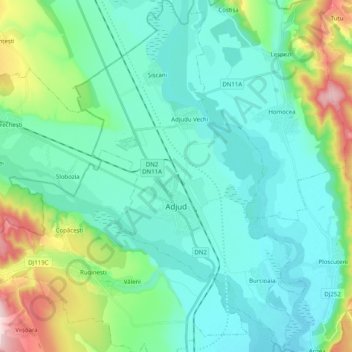
Name: Adjud topographic map, elevation, terrain.
Location: Adjud, Vrancea, Romania (46.04291 27.12362 46.18147 27.25442)
Average elevation: 138 m
Minimum elevation: 77 m
Maximum elevation: 371 m
Thank you for supporting this site ❤️
Make a donation
Make a donation
Other topographic maps
Click on a map to view its topography, its elevation and its terrain.