
Make a donation
Guayanilla topographic map
Click on the map to display elevation.
Make a donation
Guayanilla
Guayanilla is located on the southern coast. The coastline forms the Guayanilla Bay, one of the best natural harbors in Puerto Rico, to the south, also. The nearest city is Ponce, which is 12 miles (19 km) to the east. The northern regions are bordered by mountains that reach 3,300 feet (1,000 m) at the Cordillera Central. In the central regions, the terrain descends where it does not exceed 1,410 feet (430 m). Finally in the coastal plain, the elevations do not exceed 951 feet (290 m). The Yauco, Guayanilla, and Macaná rivers all run through the municipality. The Yauco River briefly runs through the Boca ward in Guayanilla, where its exit into the Caribbean Sea and accompanying marshlands are located.
Make a donation
About this map
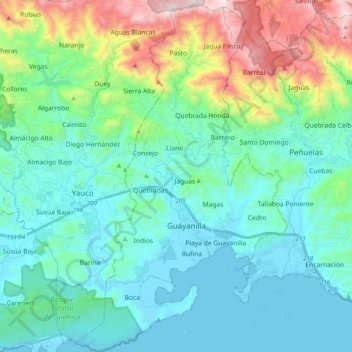
Name: Guayanilla topographic map, elevation, terrain.
Location: Guayanilla, Puerto Rico, United States (17.94968 -66.85261 18.13873 -66.73292)
Average elevation: 237 m
Minimum elevation: -1 m
Maximum elevation: 1,088 m
Make a donation
Other topographic maps
Click on a map to view its topography, its elevation and its terrain.
Make a donation
Make a donation
Make a donation
Isla de Mona
United States > Puerto Rico > Mayagüez
Mona is a mainly flat plateau surrounded by sea cliffs. It is composed of dolomite and limestone with many caves found throughout. With an arid climate and untouched by human development, many endemic species inhabit the island, such as the Mona ground iguana (Cyclura cornuta stejnegeri). Its topography,…
Average elevation: 26 m
Make a donation
Make a donation
Make a donation
Make a donation
Make a donation
Make a donation
Cayey
United States > Puerto Rico > Cayey
Cayey's climate is humid, rainy and mild compared to lower-elevation areas of the island, the area of the town is nearly 1,500 feet (460 m) high, so the climate is subtropical high. In summer average high Temperatures are around 82 °F to 88 °F and 70 °F to 78 °F in winter, and low around 68 °F to 72 °F…
Average elevation: 489 m
Make a donation
Gozalandia Waterfall
United States > Puerto Rico > San Sebastián > San Sebastián
Average elevation: 176 m
Make a donation
Make a donation
Make a donation
Ceiba
United States > Puerto Rico > Ceiba
The highest point in the municipality is Pico del Oeste in the Sierra de Luquillo at 3,346 feet (1,020 m) of elevation.
Average elevation: 50 m
Mayagüez
United States > Puerto Rico > Mayagüez
Mayagüez has a tropical monsoon climate (Köppen climate classification Am). The city has the most extreme weather of the island. The high frequency of severe storms in the summer can produce strong winds, floods, waterspouts, and sometimes hail and even tornadoes. The average annual temperature is 75 °F (24…
Average elevation: 93 m
Make a donation
Make a donation
Cerro de Punta
United States > Puerto Rico > Ponce
The mountain is part of the Cordillera Central and is located on the border between the municipalities of Jayuya and Ponce. The access road to the point closest to the highest elevation is from the municipality of Jayuya. It is part of the Toro Negro Forest Reserve, and it has been described as "an alpine…
Average elevation: 1,021 m
Make a donation
Make a donation
Villalba
United States > Puerto Rico > Villalba > Villalba
Villalba is located in the central region of Puerto Rico, on a valley in the Cordillera Central. The highest point in the municipality is Cerro El Bolo at 3,526 feet (1,075 m) of elevation.
Average elevation: 406 m
Make a donation
Make a donation
Make a donation