
Borah Peak topographic map
Click on the map to display elevation.
About this map
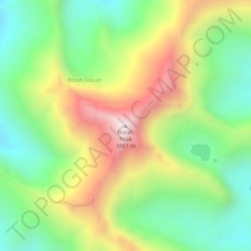
Name: Borah Peak topographic map, elevation, terrain.
Location: Borah Peak, Custer County, Idaho, United States (44.13733 -113.78114 44.13743 -113.78104)
Average elevation: 3,280 m
Minimum elevation: 2,895 m
Maximum elevation: 3,849 m
Other topographic maps
Click on a map to view its topography, its elevation and its terrain.
Stanley
United States > Idaho > Custer County
Stanley is located at 44°13′0″N 114°56′16″W / 44.21667°N 114.93778°W / 44.21667; -114.93778 (44.216698, -114.937814), at an elevation of 6,253 feet (1,906 m) above sea level
Average elevation: 1,931 m
Mackay
United States > Idaho > Custer County
Mackay is located at 43°54′43″N 113°36′49″W / 43.91194°N 113.61361°W / 43.91194; -113.61361 (43.911880, -113.613669), at an elevation of 5,905 feet (1,800 m).
Average elevation: 1,811 m
Challis
United States > Idaho > Custer County
Challis is located at 44°30′15″N 114°13′42″W / 44.50417°N 114.22833°W / 44.50417; -114.22833 (44.504260, -114.228279), at an elevation of 5,253 feet (1,601 m) above sea level.
Average elevation: 1,626 m
Redfish Lake
United States > Idaho > Custer County
The surface elevation of Redfish Lake is 6,547 feet (1,996 m) above sea level. The lake is 4.5 miles (7.2 km) long and 0.72 miles (1.2 km) wide, with a maximum depth of 387 feet (118 m), and 11 miles (18 km) of shoreline. The actual trail around the lake is 17.5 miles (28 km) in length.
Average elevation: 2,144 m
Edith Lake
United States > Idaho > Custer County
With a surface elevation of 8,660 feet (2,640 m) above sea level, Sawtooth Lake often remains frozen into early summer.
Average elevation: 2,688 m
Stanley
United States > Idaho > Custer County
In latitude and elevation, Stanley's weather station is a near-perfect twin of the station at the summit of Mt. Washington in New Hampshire. But although both are quite cold, their climates are very different.
Average elevation: 1,931 m
Mackay
United States > Idaho > Custer County
Mackay is located at 43°54′43″N 113°36′49″W / 43.91194°N 113.61361°W / 43.91194; -113.61361 (43.911880, -113.613669), at an elevation of 5,905 feet (1,800 m).
Average elevation: 1,811 m