
Sublette County topographic map
Interactive map
Click on the map to display elevation.
About this map
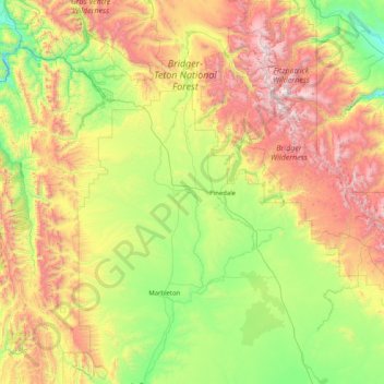
Name: Sublette County topographic map, elevation, terrain.
Location: Sublette County, Wyoming, United States (42.26328 -110.62614 43.46494 -109.04309)
Average elevation: 2,520 m
Minimum elevation: 1,775 m
Maximum elevation: 4,090 m
Other topographic maps
Click on a map to view its topography, its elevation and its terrain.
Saratoga
United States > Wyoming > Carbon County
Saratoga, Carbon County, Wyoming, 82331, United States
Average elevation: 2,086 m
Ranchettes
United States > Wyoming > Laramie County > Cheyenne
Ranchettes, Cheyenne, Laramie County, Wyoming, 82009, United States
Average elevation: 1,871 m