
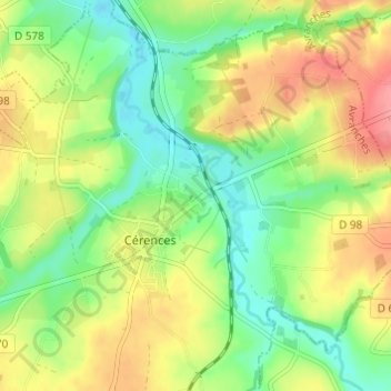
Les Carrières topographic map
Interactive map
Click on the map to display elevation.
About this map
Name: Les Carrières topographic map, elevation, terrain.
Average elevation: 49 m
Minimum elevation: 14 m
Maximum elevation: 94 m
Other topographic maps
Click on a map to view its topography, its elevation and its terrain.
La Tannerie
France > Normandie > Manche > Cérences
La Tannerie, Cérences, Avranches, Manche, Normandie, France métropolitaine, 50510, France
Average elevation: 52 m
L'Hôtel au Roy
France > Normandie > Manche > Cérences
L'Hôtel au Roy, Cérences, Avranches, Manche, Normandie, France métropolitaine, 50510, France
Average elevation: 51 m
L'Hôtel Boschet
France > Normandie > Manche > Cérences
L'Hôtel Boschet, Cérences, Avranches, Manche, Normandie, France métropolitaine, 50510, France
Average elevation: 49 m
Hameau Girot
France > Normandie > Manche > Cérences
Hameau Girot, Cérences, Avranches, Manche, Normandie, France métropolitaine, 50510, France
Average elevation: 55 m