
Waffenrod topographic map
Interactive map
Click on the map to display elevation.
About this map
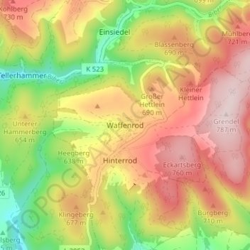
Name: Waffenrod topographic map, elevation, terrain.
Average elevation: 642 m
Minimum elevation: 475 m
Maximum elevation: 788 m
Other topographic maps
Click on a map to view its topography, its elevation and its terrain.
Sachsenbrunn
Deutschland > Thüringen > Landkreis Hildburghausen > Eisfeld
Sachsenbrunn, Eisfeld, Landkreis Hildburghausen, Thüringen, 98678, Deutschland
Average elevation: 610 m
Hinterrod
Deutschland > Thüringen > Landkreis Hildburghausen > Eisfeld
Hinterrod, Eisfeld, Landkreis Hildburghausen, Thüringen, 98666, Deutschland
Average elevation: 621 m