
Abra topographic map
Interactive map
Click on the map to display elevation.
About this map
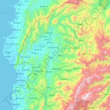
Name: Abra topographic map, elevation, terrain.
Location: Abra, Cordillera Administrative Region, Philippines (17.14975 120.45971 17.96060 121.12157)
Average elevation: 601 m
Minimum elevation: -1 m
Maximum elevation: 2,545 m
Other topographic maps
Click on a map to view its topography, its elevation and its terrain.