
Gamet topographic map
Interactive map
Click on the map to display elevation.
About this map
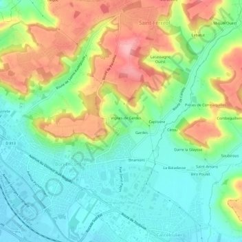
Name: Gamet topographic map, elevation, terrain.
Average elevation: 97 m
Minimum elevation: 47 m
Maximum elevation: 181 m
Other topographic maps
Click on a map to view its topography, its elevation and its terrain.
Faget
France > Nouvelle-Aquitaine > Lot-et-Garonne > Bon-Encontre
Faget, Bon-Encontre, Agen, Lot-et-Garonne, Nouvelle-Aquitaine, France métropolitaine, 47240, France
Average elevation: 126 m
La Caminade
France > Nouvelle-Aquitaine > Lot-et-Garonne > Bon-Encontre
La Caminade, Bon-Encontre, Agen, Lot-et-Garonne, Nouvelle-Aquitaine, France métropolitaine, 47240, France
Average elevation: 142 m