
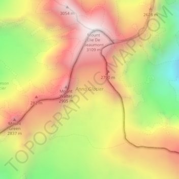
Anna Glacier topographic map
Interactive map
Click on the map to display elevation.
About this map
Name: Anna Glacier topographic map, elevation, terrain.
Location: Anna Glacier, Mackenzie District, Canterbury, New Zealand (-43.49947 170.31899 -43.48165 170.33561)
Average elevation: 2,446 m
Minimum elevation: 1,652 m
Maximum elevation: 3,086 m
Other topographic maps
Click on a map to view its topography, its elevation and its terrain.
Halswell-Hornby-Riccarton Community
New Zealand > Canterbury > Christchurch City
Halswell-Hornby-Riccarton Community, Christchurch City, Canterbury, New Zealand
Average elevation: 49 m
Methven
New Zealand > Canterbury > Methven
Methven, Ashburton District, Canterbury, 7730, New Zealand
Average elevation: 322 m
Dennistoun Glacier
Dennistoun Glacier, Mackenzie District, Canterbury, New Zealand
Average elevation: 2,026 m
Mount Hutt
Mount Hutt, Ashburton District, Canterbury, New Zealand
Average elevation: 1,732 m
Te Hīwai / Murchison Glacier
Te Hīwai / Murchison Glacier, Mackenzie District, Canterbury, New Zealand
Average elevation: 1,875 m
Christchurch
New Zealand > Canterbury > Christchurch City
Christchurch, Christchurch City, Canterbury, New Zealand
Average elevation: 41 m
South Island
South Island, Ashburton District, Canterbury, New Zealand
Average elevation: 201 m
Mount Dampier
Mount Dampier, Mackenzie District, Canterbury, New Zealand
Average elevation: 2,847 m
Maud Glacier
Maud Glacier, Mackenzie District, Canterbury, New Zealand
Average elevation: 1,711 m
Aida Glacier
Aida Glacier, Mackenzie District, Canterbury, New Zealand
Average elevation: 1,999 m
Mount Vancouver
Mount Vancouver, Mackenzie District, Canterbury, New Zealand
Average elevation: 2,804 m
Godley Glacier
Godley Glacier, Mackenzie District, Canterbury, New Zealand
Average elevation: 1,579 m
Mount Cook
Mount Cook, Mackenzie District, Canterbury, New Zealand
Average elevation: 2,920 m
Cascade Glacier
Cascade Glacier, Mackenzie District, Canterbury, New Zealand
Average elevation: 2,106 m
Tasman Glacier
Tasman Glacier, Caroline hut to ball hut, Mackenzie District, Canterbury, New Zealand
Average elevation: 1,781 m