
Papeete topographic map
Interactive map
Click on the map to display elevation.
About this map
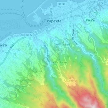
Name: Papeete topographic map, elevation, terrain.
Average elevation: 216 m
Minimum elevation: -2 m
Maximum elevation: 1,133 m
Other topographic maps
Click on a map to view its topography, its elevation and its terrain.
Tarahoi
France > Polynésie française > Papeete
Tarahoi, Papeete, Îles du Vent, Polynésie française, 98714, France
Average elevation: 35 m