
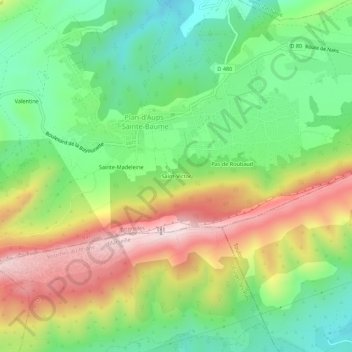
Saint-Victor topographic map
Interactive map
Click on the map to display elevation.
About this map
Name: Saint-Victor topographic map, elevation, terrain.
Average elevation: 736 m
Minimum elevation: 531 m
Maximum elevation: 1,032 m
Other topographic maps
Click on a map to view its topography, its elevation and its terrain.
Saint-Pilon
France > Provence-Alpes-Côte d'Azur > Var > Plan-d'Aups-Sainte-Baume
Saint-Pilon, Plan-d'Aups-Sainte-Baume, Brignoles, Var, Provence-Alpes-Côte d'Azur, France métropolitaine, 83640, France
Average elevation: 764 m
Le Plan
France > Provence-Alpes-Côte d'Azur > Var > Plan-d'Aups-Sainte-Baume
Le Plan, Plan-d'Aups-Sainte-Baume, Brignoles, Var, Provence-Alpes-Côte d'Azur, France métropolitaine, 83640, France
Average elevation: 720 m
Le Corps-de-Ville
France > Provence-Alpes-Côte d'Azur > Var > Plan-d'Aups-Sainte-Baume
Le Corps-de-Ville, Plan-d'Aups-Sainte-Baume, Brignoles, Var, Provence-Alpes-Côte d'Azur, France métropolitaine, 83640, France
Average elevation: 728 m
Sainte-Madeleine
France > Provence-Alpes-Côte d'Azur > Var > Plan-d'Aups-Sainte-Baume
Sainte-Madeleine, Plan-d'Aups-Sainte-Baume, Brignoles, Var, Provence-Alpes-Côte d'Azur, France métropolitaine, 83640, France
Average elevation: 741 m
Valentine
France > Provence-Alpes-Côte d'Azur > Var > Plan-d'Aups-Sainte-Baume
Valentine, Plan-d'Aups-Sainte-Baume, Brignoles, Var, Provence-Alpes-Côte d'Azur, France métropolitaine, 83640, France
Average elevation: 688 m
Réserve biologique dirigée de Sainte-Baume
France > Provence-Alpes-Côte d'Azur > Var > Plan-d'Aups-Sainte-Baume
Réserve biologique dirigée de Sainte-Baume, La Voie Royale, Plan-d'Aups-Sainte-Baume, Brignoles, Var, Provence-Alpes-Côte d'Azur, France métropolitaine, 83640, France
Average elevation: 757 m